
World Map Specifications
Page 1 of 2 • 1, 2 ![]()

World Map Specifications
![]() Toeholds Thu Apr 08, 2010 2:30 am
Toeholds Thu Apr 08, 2010 2:30 am
Since I'm not a graphic artist, I don't really know what I'm looking for other than 'something better', but here are some pointers:
Currently the map is 2116x1390 pixels wide, but I could go up to 3200x2000 quite happily.
The size of the hexes can be bigger (and in fact, should be, really).
I'd like the geographic features (mountains, rivers etc..) to be represented, but not in a way that makes the map too busy. Filetype can be anything really, it'll be flattened to a .png at the end of the day anyway.
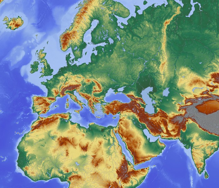
I've included 2 files; the current map file that I have as an .xcf (gimp) file with the work in layers, and another shot showing what area of the world I ideally want to represent. I'm always available to answer any questions but in the end I'd rather discussion took place there since then everyone else can see it.
Hello all (one?),
I like maps, so I figure I'll give the map a try. I have a number of other projects on the go, and this seems like a recursively exploratory effort, so this will take a few weeks.
I could not open the .xcf, but from your email, it seems like the hex-grid is baked into the image. Is that the right thing to do? I would have thought you would want the lay the grid in at game-time - for example, if you want to blink the grids (or color them) down the road to represent information.
Regardless, I see this as vector work (initially). That would give us the greatest flexibility in stylistic changes. The polishing touches would be on the rasterized image, and depending on whether you'd like a "traditional media" look, we can touch it up in PS/painter. What look would you ideally like anyway? Are there samples of artwork that comes close to what you'd like to see?
Toeholds.
Toeholds- Posts : 29
Join date : 2010-04-08
Re: World Map Specifications
![]() maximinus Thu Apr 08, 2010 9:50 am
maximinus Thu Apr 08, 2010 9:50 am
Currently the hex grid is baked in, as you say, but to change the code is trivial since I've always to use the hex grid to highlight things, show ownership and highlight regions.
What art package do you use? I can probably send it as a Photoshop file to you if you like.
Agreed about the vector image thing.
I had a look for something like what I'd like, I'd like the map look somewhat 'Roman', i.e. maybe the kind of thing you imagine an emperor having, for example:
This
Or this
But obviously a bit more geographically accurate.
My only concern right now is not having a very 'busy' map because I need to overlay visual information (soldiers, mines, mints, factories, roads, walls and so on).

maximinus- Admin
- Posts : 143
Join date : 2010-03-21
Age : 51
Location : Harbin, China -

Re: World Map Specifications
![]() Toeholds Thu Apr 08, 2010 4:08 pm
Toeholds Thu Apr 08, 2010 4:08 pm

Details:

Details, with overlaid hex-grid (+highlight). The size of the grid is approximately the same as that screenshot you had on pygame:

Better resolution versions here: overview, details, Details+Hex.
Is this somewhat close to what you want? If not, what should be changed to bring it closer to your vision? If yes, what else should be there? (rivers? cities?) How is this going to integrate/interact with other gameplay elements? What overall style (ideally) should it all come to? When you say 'roman', do you mean an old parchment, with soldiers/walls as static "boardgame pieces"? Are those pieces animated? (BTW, this map, or other subduely colored ones, probably won't play very well with the very bright cartoony colors of freeciv icons...)
Toeholds- Posts : 29
Join date : 2010-04-08
Re: World Map Specifications
![]() maximinus Thu Apr 08, 2010 11:34 pm
maximinus Thu Apr 08, 2010 11:34 pm
Toeholds wrote:Is this somewhat close to what you want? If not, what should be changed to bring it closer to your vision? If yes, what else should be there? (rivers? cities?) How is this going to integrate/interact with other gameplay elements? What overall style (ideally) should it all come to? When you say 'roman', do you mean an old parchment, with soldiers/walls as static "boardgame pieces"? Are those pieces animated? (BTW, this map, or other subduely colored ones, probably won't play very well with the very bright cartoony colors of freeciv icons...)
Wow! Well it already looks much better than what I currently have, that's a great start. Let me try to answer those questions.
Q: "Is this somewhat close to what you want?"
A: It looks better, so it is closer to what I want. However, I am a programmer and not an artist so I find it hard to express exactly what I want but easier to express what I don't like.
Q: "What else should be there?"
A: Only geographical features; anything that could be changed by people (roads, cities, bridges etc..) will be overlayed on top of the base image. However, what I'd really like if that the things that ARE overlayed should reasonably match the hex grid. So that we have mountain, hill, forest, desert and plain hexes. This would probably make the map a bit more colorful, with yellowish deserts and green forests.
Q: "What overall style (ideally) should it all come to?"
A: Again hard to say. What I do want to say is that the graphics that get blitted over the map image will act as feedback and rewards to the player; they should be able to see the effect of their player actions on the map in front of them. So near the end of the game there might well end up being a fair number of gfxs on top of the map, so I'm fairly sure I need a map that's not too busy (not filled with many contrasting colours).
Q: When you say 'roman', do you mean an old parchment, with soldiers/walls as static "boardgame pieces"? Are those pieces animated?
A: Units could be animated but only to a very small degree (to much animation -> too busy). I suppose I mean 'weathered', or perhaps 'drawn by hand' when I say "Roman" (really I mean 'old').
I've probably contradicted myself a good few times but that's because I'm a coder not an artist
maximinus- Admin
- Posts : 143
Join date : 2010-03-21
Age : 51
Location : Harbin, China -
Re: World Map Specifications
![]() Toeholds Fri Apr 09, 2010 5:04 am
Toeholds Fri Apr 09, 2010 5:04 am
maximinus wrote:Wow! Well it already looks much better than what I currently have, that's a great start. Let me try to answer those questions.
Q: "Is this somewhat close to what you want?"
A: It looks better, so it is closer to what I want. However, I am a programmer and not an artist so I find it hard to express exactly what I want but easier to express what I don't like.
It happens not only with programmers
count = 0
max_count = 5+rand(5)
while (Max.satisfy() == False && count<max_count):
TH.iterate(map)
count = count+1
Q: "What else should be there?"
A: Only geographical features; anything that could be changed by people (roads, cities, bridges etc..) will be overlayed on top of the base image. However, what I'd really like if that the things that ARE overlayed should reasonably match the hex grid. So that we have mountain, hill, forest, desert and plain hexes. This would probably make the map a bit more colorful, with yellowish deserts and green forests.
Do you mean that terrain features are drawn as (hex) tiles on top of the map? How would they work with the roads/bridges etc.? At first place, why do you need a map if there are tiles?
Q: "What overall style (ideally) should it all come to?"
A: Again hard to say. What I do want to say is that the graphics that get blitted over the map image will act as feedback and rewards to the player; they should be able to see the effect of their player actions on the map in front of them. So near the end of the game there might well end up being a fair number of gfxs on top of the map, so I'm fairly sure I need a map that's not too busy (not filled with many contrasting colours).
Q: When you say 'roman', do you mean an old parchment, with soldiers/walls as static "boardgame pieces"? Are those pieces animated?
A: Units could be animated but only to a very small degree (to much animation -> too busy). I suppose I mean 'weathered', or perhaps 'drawn by hand' when I say "Roman" (really I mean 'old').
I've probably contradicted myself a good few times but that's because I'm a coder not an artist
I think what may work well (and fast) is if I download a few icons from FreeCiv and do different (full) mock-up. That give us something to compare and contrast. I'll also try to see if I can run 0.35b on my mac... do you have any idea how to do that?
BTW, is it possible to zoom in/out of the overall map+pieces? I think a stretched out 2D parchment would look boring, but I have no idea how hard it is to code pseudo-perspective in.
Toeholds- Posts : 29
Join date : 2010-04-08
Pairwise comparisons
![]() Toeholds Fri Apr 09, 2010 1:24 pm
Toeholds Fri Apr 09, 2010 1:24 pm

Clean crisp image; full hex range. Freeciv icons; custom arrow. Garamond text. Larger version here.

Faded "parchment map"; faded hex range. Larger version here.
Which one do you like better?
Toeholds- Posts : 29
Join date : 2010-04-08
Re: World Map Specifications
![]() maximinus Fri Apr 09, 2010 11:44 pm
maximinus Fri Apr 09, 2010 11:44 pm
maximinus- Admin
- Posts : 143
Join date : 2010-03-21
Age : 51
Location : Harbin, China -
Re: World Map Specifications
![]() maximinus Sun Apr 11, 2010 11:57 pm
maximinus Sun Apr 11, 2010 11:57 pm
Toeholds wrote:BTW, is it possible to zoom in/out of the overall map+pieces? I think a stretched out 2D parchment would look boring, but I have no idea how hard it is to code pseudo-perspective in.
Don't even go there
At least in the foreseeable future, SPQR won't have this. That's not to say I don't want it, just that it isn't NEEDED right now.
maximinus- Admin
- Posts : 143
Join date : 2010-03-21
Age : 51
Location : Harbin, China -
Re: World Map Specifications
![]() Toeholds Mon Apr 12, 2010 4:19 am
Toeholds Mon Apr 12, 2010 4:19 am
And no zooming. Okie dokie. That does make a difference to what is unnecessary (in terms of resolution).
Toeholds- Posts : 29
Join date : 2010-04-08
Re: World Map Specifications
![]() maximinus Mon Apr 12, 2010 4:11 pm
maximinus Mon Apr 12, 2010 4:11 pm
Toeholds wrote:I just noticed that there is a Map database in the SPQR package. Does this mean that it will require a huge amount of effort to correct the database, if the new map does not overlap directly with the existing one? (I'm pretty sure my version of the map is of a different projection than yours...)
And no zooming. Okie dokie. That does make a difference to what is unnecessary (in terms of resolution).
There will be some work required to correct the database, but don't worry about that, it's my problem not yours
No zooming - but a mini-map will be needed, that is on the screen all the time (for rapid movement around the map).
maximinus- Admin
- Posts : 143
Join date : 2010-03-21
Age : 51
Location : Harbin, China -
Release Early and Often
![]() Toeholds Mon Apr 12, 2010 5:23 pm
Toeholds Mon Apr 12, 2010 5:23 pm
Do you use google wave? It may be a good way of collaborating on SPQR.
Zipped assets here
Toeholds- Posts : 29
Join date : 2010-04-08
Re: World Map Specifications
![]() maximinus Mon Apr 12, 2010 6:39 pm
maximinus Mon Apr 12, 2010 6:39 pm
As for google wave, I don't use it but I'm not averse to using good tools to help. However, I currently live in China and google services here can be a little patchy at times.
maximinus- Admin
- Posts : 143
Join date : 2010-03-21
Age : 51
Location : Harbin, China -
Re: World Map Specifications
![]() maximinus Tue Apr 13, 2010 9:11 pm
maximinus Tue Apr 13, 2010 9:11 pm
maximinus wrote:I currently live in China and google services here can be a little patchy at times.
And it's an issue straight away because I can't get to those zipped assets unfortunately
maximinus- Admin
- Posts : 143
Join date : 2010-03-21
Age : 51
Location : Harbin, China -
Re: World Map Specifications
![]() Toeholds Wed Apr 14, 2010 2:49 pm
Toeholds Wed Apr 14, 2010 2:49 pm
Toeholds- Posts : 29
Join date : 2010-04-08
Re: World Map Specifications
![]() maximinus Wed Apr 14, 2010 3:04 pm
maximinus Wed Apr 14, 2010 3:04 pm
maximinus- Admin
- Posts : 143
Join date : 2010-03-21
Age : 51
Location : Harbin, China -
Re: World Map Specifications
![]() maximinus Wed Apr 14, 2010 10:17 pm
maximinus Wed Apr 14, 2010 10:17 pm

I couldn't use the arrows since I stupidly didn;t tell you the hexes have been rotated round by 90 degrees since v0.3.5 (this is the more standard arrangement).
Only complaint really is that the map needs to cover a bigger area of the globe.
maximinus- Admin
- Posts : 143
Join date : 2010-03-21
Age : 51
Location : Harbin, China -
Re: World Map Specifications
![]() Toeholds Thu Apr 15, 2010 9:58 am
Toeholds Thu Apr 15, 2010 9:58 am
Rotating arrows is not a big deal, since I kept a copy of every step. Is it preferable to use the current arrangement (every arrow is part of a much larger square), or would it be better to isolate the individual arrows without the backdrop?
Making the map bigger could be a big deal, since I don't have the elevation data in hand outside this area (and vector versions are hard to come by). I'll look around and see if I can find any free ones hanging out. How far should it extend? Eventually, do you need rivers/lakes on the map?
How are the hexes currently drawn? (dynamically on the canvas, or as png?) I think I prefer to see them fainter - at least the ones not related to the action. It looks very "caged" ATM. Is it possible to highlight the current square?
Toeholds- Posts : 29
Join date : 2010-04-08
Re: World Map Specifications
![]() maximinus Thu Apr 15, 2010 1:29 pm
maximinus Thu Apr 15, 2010 1:29 pm
Toeholds wrote:Rotating arrows is not a big deal, since I kept a copy of every step. Is it preferable to use the current arrangement (every arrow is part of a much larger square), or would it be better to isolate the individual arrows without the backdrop?
The current format saves a bit of fiddly number checking in the code, so I'd rather keep it that way.
Toeholds wrote:Making the map bigger could be a big deal, since I don't have the elevation data in hand outside this area (and vector versions are hard to come by). I'll look around and see if I can find any free ones hanging out. How far should it extend? Eventually, do you need rivers/lakes on the map?
There's a picture on the first page of this thread that shows you the extent needed. This is pretty non-negotiable as well; missing the extra areas would be like a game about America missing the whole west coast!
Toeholds wrote:How are the hexes currently drawn? (dynamically on the canvas, or as png?) I think I prefer to see them fainter - at least the ones not related to the action. It looks very "caged" ATM. Is it possible to highlight the current square?
They are just overlayed with the gimp, not drawn by the game. The current square is not highlighted. Both of these things could be changed reasonably easily though.
maximinus- Admin
- Posts : 143
Join date : 2010-03-21
Age : 51
Location : Harbin, China -
Some parallel progress on a different approach
![]() Toeholds Sun Apr 18, 2010 2:58 pm
Toeholds Sun Apr 18, 2010 2:58 pm
Vectorizing this is the wrong choice - my machine chokes on it. At the moment I have in hand an image that looks like this.
At this point, I can either take this forward and generate a map from it that looks like the existing one, or into other rendering (e.g., watercolor/pencil like). There's no easy, automatic way forward. Before going on, we need to figure out how the different pieces of SPQR fits together... assuming that the 64x64px freeciv pieces are not in the final SPQR game.
Toeholds- Posts : 29
Join date : 2010-04-08
Re: World Map Specifications
![]() maximinus Mon Apr 19, 2010 12:19 am
maximinus Mon Apr 19, 2010 12:19 am
From a gaming perspective, I think we need ROUGHLY 40 to 50 miles per hex as a land resolution.
SPQR will always have the same map, because the area of the world will not change. Because of this, I always envisaged that the map would be custom built, as opposed to a lot of games that have forest/mountain/sea/etc.. hexes that are applied to some generated map.
However, internally SPQR will still need to record what any particular hex actually is, so it would be good in some way to make that distinction relatively clear on the map.
And to add to that:
Rivers would need to be based along hex borders.
There are some areas of the map where 2 land borders are split by a thin strip of ocean, and it would be good to make sure a hex line seperates them. I'm thinking mainly of Gibraltar and Istanbul, but there are a few other places. This might have be 'fudged' by altering the area by hand.
On top of the map we need to blit various things: the units, cities, mines, mints, roads, ports and so on, so I don't want the map to look too busy to start with.
Finally, I also understand that that's a lot of requests!

maximinus- Admin
- Posts : 143
Join date : 2010-03-21
Age : 51
Location : Harbin, China -
Re: World Map Specifications
![]() Toeholds Mon Apr 19, 2010 7:13 am
Toeholds Mon Apr 19, 2010 7:13 am
Resolution. I agree that 50km/hex is approximately the right scale in the gameplay. I don't know how you're going to achieve that mechanistically. The area you're looking to cover is approximately 4800x3000km in size (90 hexes across, 60 hexes down).
On the other side of the equation is the representation of the hexes on the screen. From looking at the units, the scale is currently ~1.5px/km. I find this on the too-low-resolution side, and think it would look better if each hex can be represented at higher resolution. A unit, a port, and a city should all be blittable on the same hex, and 60x60px is not alot of real estate to show all that.
However, even at 1px/km, that's already a 4800x3000 image. If we want higher resolution, say, 2px/km, it would have to become a 9600x6000px image (57Mpx). That seems to be very high for a game image.
Mapping info to tiles. While I can pull out forest/swamps/grassland info the same way I did the terrain, there is no way to graphically represent all this consistently on a map (and if we were fully consistent, it would end up looking like a tiled map). In any case... you're talking about assigning 5400(!) unique hexes of info. Are you sure you want to do that?
Rivers. The truth of the matter is, there are rivers within most (populated) hexes. I suspect we will simply draw in rivers as they suit gameplay, rather than for any geographical accuracy.
In any case, I've play around with different looks a little. I think we need to dull down the map from the raw data a fair bit (so the "blits" standout), but I'm not sure how much we can get away with before it looks "too dull".

Toeholds- Posts : 29
Join date : 2010-04-08
Re: World Map Specifications
![]() maximinus Mon Apr 19, 2010 11:16 pm
maximinus Mon Apr 19, 2010 11:16 pm
A single hex only needs to hold one 'thing' + an overlayed unit. A single REGION, which consists of 7-12 hexes, can contain 1 city, 1 mine, 1 port and maybe 1 or 2 other things.
The memory usage for the map will be twice the file size in-game. So even if it was 57M, that's still only 114M. I think most computers nowadays can handle that; I don't see any particular problem with the game requiring 300M of memory or so.
The only hex attributes I thought to have were Mountain, Forest, Plain and sea - with most being plains.
The sea has NO hexes and is simply split into regions (boats will not be hex based).
I hope that all makes sense
maximinus- Admin
- Posts : 143
Join date : 2010-03-21
Age : 51
Location : Harbin, China -
Re: World Map Specifications
![]() Toeholds Tue Apr 20, 2010 5:07 am
Toeholds Tue Apr 20, 2010 5:07 am
Toeholds- Posts : 29
Join date : 2010-04-08
Re: World Map Specifications
![]() maximinus Tue Apr 20, 2010 9:06 am
maximinus Tue Apr 20, 2010 9:06 am
Toeholds wrote:Alright. Damn the torpedoes; full-steam ahead. On assigning the hexes, one of the things we (you) could do is to add in a little interface that allows players/testers to reassign values to the database while in the game. Many eyeballs solve big problems, and this would allow for future extensions, if we're so inclined.
One of the goals for 0.3.6 is right-click sensitive menus: it'll appear under there if debugging mode is on, so don't worry too much!
maximinus- Admin
- Posts : 143
Join date : 2010-03-21
Age : 51
Location : Harbin, China -
First serviceable map
![]() Toeholds Tue Apr 20, 2010 5:24 pm
Toeholds Tue Apr 20, 2010 5:24 pm
I've just sent Maximinus the first serviceable map. I'm not entirely happy with it, but it will have to do for now. I liked the thought of a board-game, where the other "pieces" are more substantial and well-rendered, and "sit on" a paper map that is supposed to look pencil/watercolor-like. ATM the edges are too weak, but there is no good way to correct it other than drawing all of it over again. We may yet do that - but not right now.
Game-mechanics wise, there is approximately the cream/green/brown/blue colors to indicate plains/forest/mountains/water. It should still be light and airy enough for other icons to blit through (my lighting in the room isn't very good). The rivers are drawn, but we may want to add a more defined layer to it later once the hex-grids are in. And that, I'll leave in your hands, M.
I took out the screenshot - it really only looks (almost) right at scale. You should be able to see this in some later version of SPQR... 0.3.6?
Toeholds- Posts : 29
Join date : 2010-04-08
Page 1 of 2 • 1, 2 ![]()
|
|
|